Introduction
Thank you for visiting this website to find out more about the proposed Warrington Western Link (WWL). The proposed WWL will link the A56 Chester Road in Higher Walton with the A57 Sankey Way in Great Sankey. You can view the route under the 'Proposed Route' Section.
On mobile phones, some of our text may not fit on your screen, you can scroll within each of these boxes to read more.
As you scroll down, you will be able to read about why the scheme is being proposed and how the link road will improve traffic congestion in the Borough. Each section will outline and explain a different aspect of the proposals, such as the many benefits of the proposed WWL for local residents and businesses.
As a major infrastructure proposal, it is essential that residents, businesses, and other stakeholders are given the opportunity to view the proposals and provide their feedback. The current Coronavirus related restrictions do not permit traditional public exhibitions to be held. In view of these restrictions, we have developed this online engagement so that you can:
- Ask questions
- Provide feedback regarding the proposals
- Learn about the proposed Warrington Western Link road
The boundary of the proposed route is shown outlined in red on the Map.
Background
Warrington Borough Council is committed to improving Warrington for the benefit of residents, businesses, and visitors. Over the last 10 years, Warrington has experienced significant growth which has led to increased traffic congestion.
The Department for Transport has awarded the Council funding to develop a business case for the new WWL.
In 2017, a public engagement exercise was conducted on numerous proposed routes for the WWL to help identify the preferred route. Following the feedback received from the public engagement exercise, as well as technical assessments undertaken, the scheme, formerly known as the Red Route, was chosen as the proposed route. All of the routes the Council consulted on were reviewed in a multi‐criteria appraisal known as INSET, which matches the Department for Transport’s appraisal guidance. This considers factors such as the design, cost, deliverability, equality, environmental impact, and social impact as well as the public engagement response, cost‐benefit analysis undertaken and other factors. This route performed best based on this appraisal process.
In 2019, the Department for Transport informed the Council that the scheme had been conditionally awarded £142.5 million. The total estimated build cost is £212 million. Warrington Borough Council’s Cabinet agreed to accept this offer in 2019. A major scheme business case is now being prepared and will be submitted in late 2022.
What's Changed?
Since the last public engagement period, we have made a number of changes to the proposed route. We have taken on board comments we received and have improved the scheme.
These changes are summarised below:
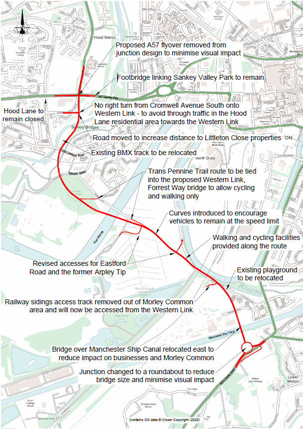
- The junction between the southern terminal of the Western Link and the A56 has been changed from a three-arm signalised junction to a large diameter three-arm signalised roundabout, in order to create greater space to accommodate vehicles. The roundabout is generally proposed to be supported on an embankment rather than a structure to minimise the visual impact of the new junction. Planting is proposed to be provided within the central island of the roundabout to improve biodiversity and create an attractive gateway to Warrington.
- The Manchester Ship Canal Viaduct has been moved approximately 9m to the east.
- The access to the Network Rail sidings, which is situated on the eastern side of the Walton Viaduct, is proposed to be provided directly from the WWL to remove the requirement for a new road to be extended across Morley Common.
- The section of highway that extends across Arpley Meadows has been horizontally realigned to avoid encroaching upon the Arpley Landfill Site to avoid contaminated land. The resulting alignment has been designed to encourage vehicles to obey the proposed 40mph speed limit.
- The intermediate roundabout that was proposed to provide access to PQ Silicas has been replaced with two island junctions, which will provide access to the Arpley Landfill Site and PQ Silicas, respectively. The alternative junction form will remove the requirement for vehicles travelling along the route to give way to vehicles performing right turn manoeuvres.
- The orientation of the bridge over the River Mersey has been adjusted to allow the highway on the western side of the river to avoid the pylon and thereby minimise the extent of utility diversions. The resulting bridge alignment also enables piles for new piers and abutments to be installed without introducing a requirement for piling rigs to work below the overhead electricity lines.
- The existing bridge over Forrest Way is proposed to be retained and the space within the existing highway is proposed to be reallocated to accommodate active travel routes. This approach will create a segregated, traffic-free route for pedestrians and cyclists to cross the River Mersey and it will enable the width of the new bridge over the Mersey to be reduced.
- The section of highway that extends across the Mersey Meadows has been horizontally realigned to increase the distance to existing properties that are situated on the northern side of Forrest Way.
- The highway that extends through Sankey Valley Park has been horizontally realigned to increase the distance to properties within Littleton Close.
- The junction between the northern terminal and the A57 has been changed from a flyover at Sankey Way to a larger four-way signalised junction to reduce the visual impact of the new junction. The signalised junction is proposed to incorporate controlled crossings to allow pedestrians and cyclists to safely negotiate the junction.
- Active travel routes for pedestrians and cyclists have been improved by generally providing a single 5m wide segregated footway/cycleway along one side of the carriageway, rather than two shared footway cycleways on either side of the carriageway. This approach is intended to encourage the use of sustainable modes of transport, as the segregated route will enable cyclists to travel at higher speeds, whilst also reducing the likelihood of conflicts with pedestrians.
Proposed Route
The proposed WWL will link the A56 Chester Road in Higher Walton with the A57 Sankey Way in Great Sankey.
Scheme Objectives
The Warrington Western Link represents significant investment in our Borough. The proposed Western Link will bring many benefits to local residents and the local economy. The objectives of the programme, as detailed in the Outline Business Case to Department for Transport, are to deliver the following:
- Relieve congestion and improve air quality in Warrington Town Centre
- Reduce volumes of through traffic passing through the town centre.
- Free up town centre capacity for bus, public realm, and active travel improvements.
- Relieve severe pinch points on the network, including Bridgefoot Gyratory and Brian Bevan Roundabout.
- Contribute to improved air quality in the Warrington Town centre Air Quality Management Area.
- Improve connectivity between North and South Warrington
- Improve local connectivity, by delivering additional route choice and reducing the barrier effect caused by the River Mersey, Manchester Ship Canal, and railway lines.
- Improve the strategic connectivity, by making Warrington more resilient in case of incidents on the Motorways.
- Unlock key development land to support the growth aspirations of ‘Warrington
Means Business’ and the Warrington Local Plan
- Deliver access to the next phase of the Warrington Waterfront Masterplan.
- Deliver improved access to Port Warrington.
- Deliver access and capacity to support new housing developments.
- Deliver access and capacity to support the development of employment land.
- Support the continued growth of Warrington’s economy within the Northern
Powerhouse
- Deliver journey time savings for commuters travelling into, out of and within Warrington.
- Provide better access to growing employment sites in and around Warrington, including Omega, Lingley Mere, Sci‐Tech Daresbury, Warrington town centre and Birchwood.
- Make Warrington a more attractive place to live
- Provide access to new green and recreational space between the River Mersey and the Manchester Ship Canal.
- Support the implementation of new public transport and active travel routes associated with the Warrington Waterfront development.
- Support the Warrington Health and Wellbeing Strategy’s vision to work together for stronger neighbourhoods, healthier people, a vibrant and resilient economy, and greater equality across all our communities.
Benefits
In achieving these objectives, we are confident that the following benefits will be delivered:
- Reduced traffic entering the town centre to access northern and southern sites within Warrington.
- Less congestion in central Warrington.
- Reduction in vehicular greenhouse gas emissions and improve air quality in the town centre.
- Reduction in congestion across the wider highways network.
- Reduced impact of Manchester Ship Canal bridge on traffic flows across Warrington.
- Extra route choice and highways resilience associated with another crossing of the Manchester Ship Canal.
- The reduction in congestion and improved traffic flow will lead to significant economic benefits.
- Deliver access to the proposed Waterfront development and help revitalise Warrington’s riverside environment into an exciting destination for proposed new residential housing, employment, and recreational space.
- Deliver access to the proposed Port of Warrington intra‐modal freight facility.
- Warrington Western Link could help unlock housing and employment sites in south‐west Warrington, associated with the draft Local Plan.
- The WWL has the potential to contribute to:
- The creation of over 350 net additional jobs and millions of pounds of net additional GVA per annum; and
- Bringing forward a significant number of new homes over the local plan period. The construction of the dwellings has the potential to generate a temporary economic impact of over 100 construction jobs and significant GVA per annum during the construction period.
- The tax impact of developing these sites to Warrington Borough Council is:
- An additional £2m in business rates per annum; and
- Approximately £1m in additional Council Tax each year.
- The total value of this intervention in GVA modelled over 30 years, in 2010 prices, discounted to 2010, is an NPV of £137.63m.
- Improved accessibility to homes, jobs, and leisure sites on Old Liverpool Road, A56, Daresbury and onto the M56.
- Helping to bring forward the redevelopment of the leisure parkland at Arpley Landfill.
- Reduced vehicles entering the town centre and reduction in vehicle greenhouse gas emissions.
- Helping to raise active travel in Warrington through the addition of a cycle lane alongside the Western Link
Feedback and Next Steps
Thank you for taking the time to view this virtual exhibition for the Warrington Western Link proposals. You can provide feedback to us in the following ways:
- Complete a Feedback Form
- Take part in our Question and Answer Session, by providing your questions using the contact details provided.
- Email any comments or queries to warringtonwesternlink@havingyoursay.co.uk
- Phone our dedicated freephone community telephone line 0333 358 0502 (Monday to Friday, 9:00am to 5:30pm)
Please note that any feedback submitted to this public engagement exercise is not a direct representation to the planning authority. Once a planning application is submitted, there will be an opportunity to make such representations to the planning authority.
All comments should be received by 23rd December 2020.